Release time:2019-12-23 17:58:10 Number of reading:3265
|
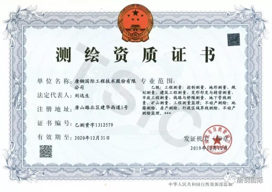
Recently the good news that TSIC has successfully passed the application for promotion of surveying and mapping qualification and obtained the qualification of surveying and mapping Class B came from the department of natural resources of Hebei province, marking that the service level, business scope and comprehensive competitiveness of surveying and mapping geographic information of TSIC has been substantially improved .
The general layout department of TSIC elaborated qualification declaration materials according to the provincial natural resources qualification reporting requirements since the qualification upgrade of surveying and mapping took hold in November 2019,invited relevant experts to strengthen the construction of surveying and mapping engineering talent team, increased surveying and mapping equipment investment, and successfully passed the on-site audit of Tangshan natural resources and planning bureau experts. Eventually TSIC obtained the surveying and mapping qualification certificates Class B in 12th,December 2019 after approved by the province natural resources experts and publicized.
The success of the qualification upgrade laid a solid foundation of expanding the contracting and provided the qualification guarantee for the business promotion of TSIC for the next step. The general layout department of TSIC will continue to enter Class A based on the existing foundation, gradually increase the aerial remote, sensing geographic information and satellite real-time monitoring and strive to build a well-equipped technology leading style excellent high levels of surveying and mapping geographic information team.
The approved scope of qualification Class B of surveying and mapping include: engineering survey: control survey, topographic survey, planning construction engineering measurement, deformation and precision measurement, Surveying supervision of surveying line of municipal engineering and underground pipeline of bridge and tunnel surveying mine surveying engineering; Real estate surveying and mapping: cadastral surveying and mapping real estate surveying and mapping administrative boundaries surveying and mapping real estate surveying and mapping supervision.
|
Contact us
No. 599 Ronghua Road, Tangshan City, Hebei

Tel:0315-7252515
Fax:0315-7252101
Email:[email protected]
About us Chairman History Leadership Organizational Responsibility Big event Picture album
Our service Honor Technical display Project display Award-winning project Expert team Patent
Core ideas Responsibility Manpower training Employee demeanor
Copyright tsic.com steel international copyright 2021011326 Ji -1 ICPTechnical
support: Tangshan Transit Technology Co., Ltd.